Beginning in 2011, BioBase brought the 3rd dimension of habitat in the aquatic world to practitioners. BioBase’s EcoSound™ maps not only the mere presence of vegetation, but also the canopy height and creates aquatic plant ABUNDANCE maps of unprecedented detail (Figure 1).
Figure 1. A percent vegetation heat map shows you exactly where vegetation is most dense and helps target management or protection.
We’ve spent thousands of words in these pages and presentations on the road extolling the importance of measuring and monitoring aquatic plant abundance to further the goals of aquatic habitat conservation. We place emphasis on the word “abundance” because it drives habitat; it drives water quality dynamics. Abundance carries additional meaning than whether something is simply present. Measuring how many of something is in a space is generally harder than concluding whether that same something is present or absent. Yet, simply existing carries great importance as well. So while abundance is critical to know for population viability and ecosystem models, knowing whether a species is simply occupying a space regardless of its abundance is also tremendously important.
In the 14+ years BioBase has been in service, we’ve seen our share of sonar logs and maps (both good and bad). We’ve learned some things and improved back-end processes that have resulted in you getting better maps processed faster. But we’ve also learned from you, our users, about strategies and techniques that result in better outcomes, and what to avoid. Here are eight of those lessons learned:
1. Good transducer installation is critical
You could be the most experienced hydrographer in the world and execute the perfect survey design, but your map will be mostly worthless if your transducer is not securely attached to your boat or is slanted at an angle. We’ve devoted a fair amount to this topic in previous blogs, so we won’t dwell on it here. The two key take aways are: 1) ensure the transducer is installed straight in all directions and leveled keeping in mind the slant of the hull in the water fully loaded. Replicate that tilt with your tongue jack when installing your transducer. 2) Install the transducer where the flow of water is smooth and laminar over the transducer face at all speeds. If you lose your transducer signal as the boat speeds up, you probably have an issue with cavitation (water turbulence) around the transducer face. Adjust the transducer height (sometimes only a very small amount) or move it away from rivets or anything else near the hull that could cause cavitation. One of the benefits of working with consumer devices like Lowrance and Simrad is that there is a wealth of online self-help resources and service centers that can help you install your transducer correctly. A simple Google Search “Lowrance Transducer Installation” will turn up all the resources you need. This one from Lowrance is one of our favorites. If you have multiple survey boats and want to make your unit portable, I strongly recommend purchasing and installing multiple transducers on all of your boats rather than a portable transducer bracket. In the grand scheme of things, consumer-sonar transducers are cheap and the consistent results you will get from a firmly mounted transducer is worth it!
Figure 1. Watch for warning signs of a slanted transducer (alternating thickness of slopes, slanted vs horizontal fish arches)
Announcing EcoFish TM! A Game-Changing BioBase fish mapping layer powered by Echoview Software, the industry leader in fisheries hydroacoustic processing technology.
Now, anyone with a Lowrance® or Simrad® depth finder can generate detailed counts, depths, relative size, and location of fish. Not only that, but also at the same time with no additional work, acquire critical habitat details including surface water temperature, depth contours, bottom hardness, aquatic vegetation abundance, and detailed side-scan imagery of habitat. If you want the webinar version to learn more, check it out on our YouTube Channel, otherwise read on…
(b) BioBase Ambassador, Certified Lake Manager, and President of LakeTech Inc.
The term “Fit for Purpose” has recently become a popular term in our circles in the context of mapping and surveying water bodies, and it refers to utilizing the appropriate equipment, methods, and budget for the task at hand.
This principle acknowledges that one type of equipment and method may not be suitable for every scenario. For instance, whether you’re assessing the storage volume of municipal stormwater ponds or maintaining a river channel for commercial navigation, the required level of accuracy will and should be different. While high accuracy and precision may be crucial for certain projects, it might not be necessary for others.
Given the disdain for the word “weed,” it’s not surprising that seaweed gets such little respect in most developed human cultures. But, we are finding seaweed and its rooted cousin seagrass hold immeasurable value for the future of humankind. Time to get to work mapping it!
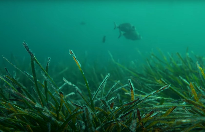
Seagrasses are considered vascular plants and have roots, stems, leaves, and flowers. According to a report from the United Nations in 2020, there are more than 70 species across the globe covering over 300,000 km2 (which is likely a vast underestimate) making them one of the most widespread coastal habitats.
Figure 1. Posidonia seagrass growing off the Mediterranean Coast of Spain. See us map it
What is BioBase? BioBase uses off-the-shelf sonar technology and automatic cloud processing to create professional bathymetry, bottom composition, and aquatic vegetation maps. BioBase removes the labor intensive and high cost elements of acquiring high quality data very quickly so you can focus your efforts on aquatic resource management.
The Professional Spotlight series is a deep dive into the global BioBase community where we highlight the unique ways sonar driven mapping is assisting research, conservation and sustainability.
The BioBase team sat down with Dr. Chris Harrod for a look into how he uses BioBase. Chris (from the UK) is a full professor of Fish and Aquatic Ecology at the University of Antofagasta in Antofagasta, Chile. He does a mixture of research, teaching, and administration tasks but our interest with him was the applied research techniques for which he was using BioBase. His research is focused on a macroalgae called kelp (aka seaweed) and its importance as a source of food/energy to fish and invertebrates in the coastal zone. He is also interested in how kelp can function as habitat, food, an anchor of sediment and even slow the turbulent waters of the Pacific Ocean.
Guest Blog by Robert M. Baker, CPG, PG (a) and Penelope R. Baker (b)
(a) Professional geologist at RMBAKER LLC and Navico BioBase Ambassador
(b) Stanford University student, Ecology and Evolutionary Biology, Wildlife Photographer
BioBase is a cloud software that directly supports the preservation of our aquatic environments. Words like preservation and conservation directly imply things like careful planning, measuring and monitoring, treatment and rehabilitation – actionable strategies for the good of animals, plants and natural resources where BioBase can play an important role. BioBase offers an opportunity to observe natural systems, like seagrasses, not easily seen otherwise and does so effortlessly and affordably.
BioBase’s EcoSound is a powerful cloud platform for creating high definition lake or coastal maps of depth, aquatic vegetation (or seagrass), and bottom hardness from Lowrance® and Simrad®
sonar systems. For the user, the process of converting volumes of raw sonar and gps signals into an intuitive map is easy and requires very little input upfront. Record your sonar while out on the water to a microSD card, plug the card into your PC back at the office, log into your BioBase account and upload. Algorithms on remote servers do the rest of the work. However, one of the most frequently overlooked parts of this equation is careful attention to the proper installation of the transducer sensor that is pinging the bottom and collecting all the information below the boat. The importance of proper transducer installation cannot be overstated. If the transducer is not properly placed on the boat or not at the appropriate angle, your BioBase outputs could be inaccurate. Researchers and Data Analysts have heard it said many times (sometimes in more colorful language), the quality of the output depends on the quality of the input.
The waters of Western Port in southeastern Australia are a recreational fishing haven and hidden beneath its turbid waters, a unique fragile seafloor community has been newly described. Here, bryozoans, skeleton-forming filter-feeding organisms also known as ‘lace corals’, form expansive areas of reef that support a high diversity and abundance of macroinvertebrates important to snapper and other prized recreational fish species.
Figure 1: Underwater imagery of the bryozoan reefs revealed remarkable biogenic reef structures with abundant invertebrate life surrounded by large areas of bare sediment.