For this Professional Spotlight the BioBase team sat down with a biologist at a power plant. They use BioBase to evaluate risk of cooling water intake blockage from aquatic vegetation. This is one of many methods they use ensure abundant cooling water is available for the redundant intake systems. In 2012, invasive zebra mussels invaded the system and paved the way for aquatic vegetation by clearing the water. They map aquatic vegetation during the growing season and use the polygon tool to measure percent area covered and biovolume in the areas of interest. Aquatic vegetation management recommendations are based on this data. Before BioBase they took samples using a rake to determine what species were present and estimate the total biovolume. Now using BioBase they can easily measure biovolume at location with ease.
When asked why they chose to use BioBase they responded, “the value, there are a lot of options out there, most are expensive, but BioBase is not.” Even at a low cost “it still produces very reliable data, BioBase is a high value product.”
The Professional Spotlight series is a deep dive into the global BioBase community where we highlight the unique ways sonar driven mapping is assisting research, conservation and sustainability.
The BioBase team sat down with Dr. Chris Harrod for a look into how he uses BioBase. Chris (from the UK) is a full professor of Fish and Aquatic Ecology at the University of Antofagasta in Antofagasta, Chile. He does a mixture of research, teaching, and administration tasks but our interest with him was the applied research techniques for which he was using BioBase. His research is focused on a macroalgae called kelp (aka seaweed) and its importance as a source of food/energy to fish and invertebrates in the coastal zone. He is also interested in how kelp can function as habitat, food, an anchor of sediment and even slow the turbulent waters of the Pacific Ocean.
Sonar technology continues to improve bringing anglers and aquatic managers better, more clear pictures of the underwater environment on which they are so intently focused. Launched in 2011, BioBase’s EcoSound technology was the first cloud aquatic mapping system designed to process sonar logs from off-the-shelf Lowrance® sonar and create maps of bathymetry, aquatic vegetation biovolume, and bottom hardness for aquatic resource professionals. Today, BioBase is the leading cloud software solution for automated lake and coastal seagrass mapping.
Between 2011 and 2014, the algorithm underwent five major revisions. The bottom hardness algorithm has undergone two major revisions, with the last one in 2014. Thus, our code base was due for an overhaul in order to maintain performance and compatibility with newer generation Lowrance and Simrad sonar. This refactoring effort was also an opportunity for us to improve the vegetation and bottom hardness algorithms. Many of these improvements also carry over sister consumer technology C-MAP Genesis, which uses many of the same algorithms and backend processing architecture
2020 has been a busy year for BioBase improvements and new feature releases. Previously exclusive to BioBase’s sister consumer mapping platform, C-MAP Genesis, BioBase users can now export their bathymetric, aquatic vegetation heatmap, or bottom hardness map in a file format (AT5) that is compatible with most newer generation Lowrance and Simrad chartplotters. This feature enables researchers and aquatic resource managers to return to surveyed areas of interest and precisely target follow-up surveys or management actions (e.g., strategic taking of water or aquatic plant samples, placement of fish habitat structures or aeration equipment, precision applications of aquatic herbicides, etc.)
In the images and captions below, we’ll walk you through how to do this in your biobasemaps.com account.
1. Export the GPS Chart file from the desired EcoSound Trip or Merge from BioBase.
In the Export Data tool, select “GPS Chart Generation”Export the desired layers
3. Unzip the downloaded file and save to a MicroSD card (<32 GB).
The layer will export as .zip with a random GUID name. The zip file must be unzipped (7-Zip is a great freeware for unzipping files) and the entire contents of the extracted zip file should be copied to a MicroSD card. The contents in the folder are propriety, encrypted files (.AT5) that are specific to the device you registered in your account. The chart file will not work in other non-registered devices. You can register multiple devices. One card can hold multiple AT5 folders (charts) and recorded sonar logs. Cards cannot be larger than 32 GB however.
2. View and Use in your Lowrance or Simrad!
Insert the card with the saved AT5 chart files. Go to the Chart and select the appropriate Chart Source in Chart Options. Voilà!Sample bottom hardness map from the same BioBase survey.If you want to view a blue- (or custom-) shaded contour map, simply uncheck the Vegetation/Composition categories in one of the Chart menus.Detailed, custom-made bathymetric chart. Note that prior to using for navigation, close attention by the user should be given to the quality of the sonar data recorded and resulting accuracy of the map.
The polygon tool is one of BioBase’s strongest features. The ability to calculate total water body, vegetation cover percentage, surface acreage, and more is crucial to environmental management. Reduce the amount of herbicide you need to apply by taking the guess work out of treatments. Pinpoint locations of beneficial vegetation plantings and monitor the success using the vegetation biovolume value created by the polygon tool. The polygon tool is one of the most versatile features and a use can be found in any area of interest. Below is a step by step walkthrough of how to use the polygon tool.
A few things to take into consideration when creating a polygon. First, polygon tool is a very data intensive feature and requires a lot of processing power. In order to limit the demand on server, we must limit simultaneous polygon requests system wide to two. After clicking save and the polygon tool begins the calculations you should see the following statement in the upper right hand corner “Generating statistics: please be patient. Response times depend on waterbody size and amount of data.”. You will also see a spinning circle indicating the tool is working this may take up to 3 minutes depending on the data and the polygon. If you receive a prompt to try again at a later time, the servers may be busy processing other polygons. Try waiting a few minutes then trying again.
Step 1. Select the “Polygon” tab
Select the Polygon Tab
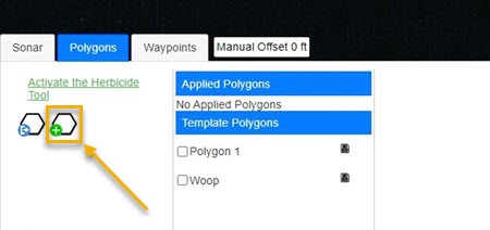
Step 2. Click create polygon button
Click create polygon button
Step 3. Name the polygon
Name the polygon (required)
Step 4. Add a description to the polygon
Add a description to the polygon
Step 5. Draw the polygon by clicking points, double click to end the drawing
Draw the polygon by clicking points, double click to end the drawing
Step 6. Save the polygon
Save the polygon
Step 7. Data Table
Example of data table generated by the polygon tool
The polygon management tool allows subscribers to create a polygon within their data for automated processing and assessment of specific boundaries within an upload. After you gather Lowrance sonar data and upload it to your BioBase account to create a bathymetric, vegetation and hardness maps, you can determine water volumes, acres, max and average depths, vegetation average biovolume percentage, vegetation cover percentage and more.
The days of estimating water volumes are over. Even though we were already providing detailed water volume analysis of the area covered, BioBase will now allow you to create and manage your treatment zones and areas of concern in greater detail. BioBase is taking lake management and habitat analysis to the next level and automating everything you need to take your collected data full circle. For more information on Navico’s sustainability initiative click Here