
Sonar technology continues to improve bringing anglers and aquatic managers better, more clear pictures of the underwater environment on which they are so intently focused. Launched in 2011, BioBase’s EcoSound technology was the first cloud aquatic mapping system designed to process sonar logs from off-the-shelf Lowrance® sonar and create maps of bathymetry, aquatic vegetation biovolume, and bottom hardness for aquatic resource professionals. Today, BioBase is the leading cloud software solution for automated lake and coastal seagrass mapping.
Between 2011 and 2014, the algorithm underwent five major revisions. The bottom hardness algorithm has undergone two major revisions, with the last one in 2014. Thus, our code base was due for an overhaul in order to maintain performance and compatibility with newer generation Lowrance and Simrad sonar. This refactoring effort was also an opportunity for us to improve the vegetation and bottom hardness algorithms. Many of these improvements also carry over sister consumer technology C-MAP Genesis, which uses many of the same algorithms and backend processing architecture
Algorithms are signal and transducer “agnostic”
Previously, accurate EcoSound (and Genesis) outputs required users to log the 200 kHz channel on 500W Lowrance transducers as the algorithm was tightly tuned to this frequency and power level. New methods use signal smoothing methods to extract features (e.g., first and second echoes, vegetation features) and are less dependent on the precise backscatter of a particular Lowrance echosounder and transducer. This improvement opens up compatibility with a greater range of higher powered Airmar transducers (Figure 1). EcoSound compatibility remains exclusive to Lowrance and Simrad echosounders (.slg, .sl2, and .sl3 file formats)

Better target separation between face of transducer and vegetation growing near the surface
High energy environments (e.g., shallow water, high turbulence, active photosynthesis by plants, cavitation (airbubbles) around the transducer due to suboptimal installation are a challenge for mapping aquatic vegetation. To the algorithm, “noise” can look a lot like vegetation and vice versa. Although the previous algorithm did have some sensitivity knobs we could turn, there was a tendency for the algorithm to mistake noise for aquatic plant growth and overestimate biovolume in some places (Figure 2a and 2b).


EcoSound is now Downscan compatible!
One of the biggest advancements in off-the-shelf sonar technology is side and down imaging, or scanning sonar, which can generate high definition images of bottom features. Although the 200 kHz primary channel is still the default channel for creating vegetation maps with EcoSound, users can choose to reprocess their trips with downscan (455 of 800 kHz) if they have a downscan compatible transducer and logged their files as .sl2 or .sl3 file formats (.slg is primary sonar only). Downscan has a narrow (2.5 degrees fore-aft) scanning beam 47 degrees wide, and sometimes can generate better images of bottom than the 22 degree flashlight-like broadband beam of the Primary 200 kHz channel.

Preliminary tests showed both channels performed well in detecting the top of vegetation growth in most cases. However, accuracy of outputs will depend on a variety of environmental conditions such as depth, water clarity, transducer install, vegetation density, etc. We recommend that users run their own tests, reprocessing a sample of trips with both channels comparing the maps with the sonar viewer and field observations, to know which channel will produce the best outputs for their use cases. Fortunately, both primary and downscan channels are logged together in the .sl2 and .sl3 file format and users can select which channel All depth measures come from the primary channel since numerous tests have determined that the 200 kHz channel is the best channel offered for tracking depth through vegetation. We don’t recommend recording 50, 83, or CHIRP Primary frequencies as they are not suitable frequencies for mapping vegetation and are thus, not supported.
More sensitive and accurate bottom hardness
The previous versions of the bottom hardness algorithm looked exclusively at characteristics of the second (false E2) echo. If it was strong/large, the bottom was interpreted to be hard. If it was absent or weak, the bottom was soft. Now, the algorithm incorporates characteristics of both the first (E1) AND second E2 echo. Our new method is similar to the “RoxAnn” method of bottom hardness assessment; Yamasaki et al. 2017). The new algorithm is more accurate and sensitive than the old algorithm over a broader range of depths. Values remain along a continuum between 0 (soft) and 0.5 (hard). The new algorithm is able to discriminate between a broader range of composition types (e.g., really soft mud, clay, soft sand, hard sand, gravel, boulder) than the previous algorithm (Figure 4.). Efforts were made to maintain consistency between old and new methods but a different equation was used with the new algorithm, so users may find differences in values and colors between old and new maps. Users should always do field checks of hardness to calibrate EcoSound outputs with field observations.

Bulk Editing Tools
Although EcoSound is more “turn-key” than ever, users may still encounter bad soundings, difficult to map environments (extremely shallow, high energy/noisy underwater environment, extremely steep slopes), or situations where debris on the bottom might be mistaken for vegetation. Map outputs can be reviewed and small or large areas can be edited through our new bulk editing tool (see “Modify Coordinates” button in uploaded EcoSound trips (feature not available for merges, Figures 5-9). Users may find this video helpful for editing vegetation maps and this video helpful for editing depth maps


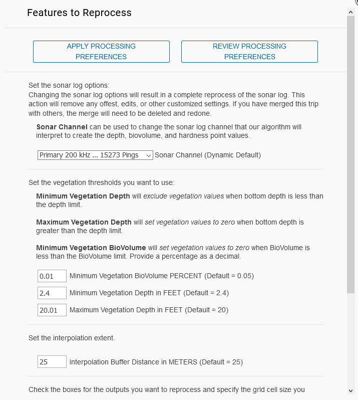
Advanced Default Processing Preferences
Users can now adjust processing settings at the account level like depth offsets, buffer, grid cell, min/max depth of vegetation detection, sonar processing channel, etc. so that every trip uploaded has your custom settings (Figure 10)! You can still change settings on a trip by trip basis as well. Read more about it here.
To inquire about other BioBase features or plans, send a message to sales@biobasemaps.com. Learn more here – https://www.biobasemaps.com/Plans.